Community Info
Long Plain First Nation
.
A signatory to Treaty One, Long Plain First Nation is a proud Ojibway and Dakota community in the central plains region of Manitoba, situated on a land base of 10,800 acres. Long Plain is comprised of a main reserve and urban economic zones, situated along the city limits of Portage la Prairie, and in the city of Winnipeg, resulting from treaty land entitlement under a 2011 settlement.
The First Nation community is governed by an elected Chief and four Councilors. The First Nation Council is elected under its own Band Custom Election Act and hold office for a three-year term. Council Members are responsible for all funds and programs, administrative and services areas, however each of Council Members are assigned and responsible for certain portfolios. The First Nation Tribal Office is located on the main reserve and Band Council meetings are held every week.
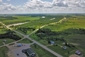
Long Plain Reserve No. 6
Long Plain Reserve No. 6 is situated in the south central area of Manitoba, known as the “Central Plains Region”. The reserve is located 14 km southwest of Portage La Prairie, and 98 kilometers west of Winnipeg and 10 kilometers south of the TransCanada Highway No. 1. The landscape of the reserve begins along the northwest and southeast banks of the Assiniboine River for approximately five miles and extending three miles west. A portion of the reserve also lies across Assiniboine River.
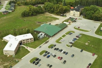
Keeshkeemaquah Reserve
In May 1981, the Band Government at the time named Short Bear Tribal Council, by Band Council Resolution requested surplus crown lands from the Department of Indian and Northern Affairs Canada as part of the outstanding treaty land entitlement owed to Long Plain Reserve.
On August 14, 1981 the 45 acres of Federal Crown land which is located adjacent to the City of Portage la Prairie, Manitoba was transferred to Long Plain Reserve. These lands are described as, In the Province of Manitoba, in Parish of Portage la Prairie, in the Long Plain Reserve No. 6 and being: those portions of River Lots 50, 51, and 52 contained within the limits of Parcel “A” as shown on a Plan of Survey filed in Portage la Prairie Land Titles Office as No. 1212, a copy recorded in the Canada Lands Surveys Records as No. 67767; said Land containing 18.31 hectares or 45 acres more or less.
The lands were originally used as an Indian Residential School called Portage la Prairie Presbyterian Indian Residential School. The lands included a two-storey brick building approximately 2,058 square metres. In 1984, the building was renovated and became home to the Yellowquill College Inc. many years. The College then moved to Assiniboine Avenue, Winnipeg in the year 2000 sixteen years later.
In 1992, the First Nation held a referendum for designating the lands and assented to by a majority of the electors of the First Nation and accepted for leasing and accepted in April 1994. In the year 2000, the LPFN Council entered into a ground or head lease with Arrowhead Development Corporation for 50 years. The lands were designated for education and training purposes.
In 2004, the Frist Nation requested to amend the purpose of the lease to allow for education training and office facility, commercial leasing ancillary purposes.
In 2008, a referendum was held to amendment the existing designation for the Yellowquill Site now called Keeshkeemaquah Reserve, to extend the ground or head lease term for additional 75 years making the term expire in 2,119.
The lands are now subleased to the Keeshkeemaquah Conference and Gaming Centre, Miskwaanakwadook Place, Arrowhead Gas Bar, Rufus Prince Building, White Cross Drugs and Walk-in Clinic and Long Plain Housing Authority.
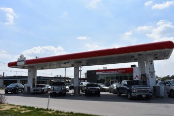
Madison Indian Reserve No. 1
In 2006, Long Plain First Nation Trust purchased 2.81 acres of prime property in the City of Winnipeg from Manitoba Hydro. The purchase included a 29,427 square foot building, 48,130 square foot asphalt parking lot and additional gravel parking lot of 42,500 square feet.
The property is situated along the 400 block of Madison Street between Silver and St. Mathews Avenue west of the Polo Park Shopping Mall.
In 2008, the First Nation held a referendum vote to seek the assent of the majority of electors of the First Nation to designate the property and on July 12, 2012 the First Nation receive pre-designation. The purpose of the designation was to lease the land and building to generate revenues for the First Nation by way of leasing. In addition, to allow for granting such easements, permits, right of way, licenses of occupation and amendments of such interests as maybe necessary or ancillary to the primary purposes of any lease entered into respecting the property.
In 2010 the First Nation and the City of Winnipeg entered into a Municipal Service Agreement to extend services to the property.
In 2011, a major portion of the building was renovated and leased to the Yellowquill College Inc. and in 2012 the remaining space renovated for office space and now lease to lease to Aboriginal Peoples Television Network Inc., Manito Abe Inc., Eagle Vision, and Manitoba Treaty Commission Office.
In 2013, the site officially attained reserve status and became Winnipeg’s first urban reserve. This was a significant milestone and it allows LPFN to unlock the true economic potential for the site. As a result of the conversion, LPFN successfully secured financing for the future development of gas bar located at the corner of Madison St. and St. Matthews Ave. The conversion also allowed LPFN to move forward with their plans to renovate the south side of Yellowquill College and lease it out to commercial tenants.
Further development of the site includes plans for the construction of a new office complex.
